|
|
|
TE KOMOKI -- JACKY’S PEAK
(But refer to the Addendum at the end of this article)
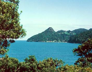 “One of the
best preserved pa sites in the Waitakere Ranges is on
“One of the
best preserved pa sites in the Waitakere Ranges is on
Te Komoki, the conical peak at the mouth of Huia Bay. The top of the peak has been carved into 12 terraces with 5 pits in them. Three sides of the pa were protected from attack by vertical rock cliffs while the fourth side has a deep ditch dug across it for defence.”
“The Maori History and Legends of the Waitakere Ranges”
By John T. Diamond and Bruce W. Hayward (1979)
The remnants of the “deep ditch” are still visible on the SW side of the peak, near the summit (if one knows where to look). It is doubtful whether the terraces and pits are now visible.
Jacky’s Peak is named after John Wade (Hake Marama). He is an important figure in the early European history of Little Huia. A record of what we know about him is contained in the book:
“Whatipu - The Story of Whatipu and Early Huia” by Bruce Harvey (2001)
To quote from that book:
“John Wade, or Hake Marama as he was named by his Maori relatives, was an Englishman who lived at Little Huia with his wife Harata (Charlotte) and their children Eliza, John, Laura, Thomas, William and Henry. He was given this land by a chief of the Ngatiata tribe called Te Kapita in exchange for land that he and Harata had previously bought on the Awhitu Peninsula near Waiuku, on the south side of the Manukau. The Awhitu land had been bought from his wife’s father, a chief of the Ngati Tamaoho tribe called Wetere Te Kauae. John Wade was also sometimes called Jacky, Hake or Haki Marama (Jack of Marama) by Maori. The Marama stream in the Little Huia valley was named after Hake Marama. The wooded rocky conglomerate knoll, which is an old Maori pa site and forms the western end of Huia Bay, was called Jackie’s (sic) Peak after Jack Wade. Wade did not have title to his land at Huia in the 1850s and in the early years of that decade he worked at Muddy Creek (Parau) pit-sawing timber. After an illness he returned to Huia and began to cut some of the timber on his property. When the government bought the Hikurangi block, which included Huia, they found Wade in occupation and this was taken into account when he was finally given title in 1862. Later he sold some of this land to the Gibbons family.” (Page 78)
According to the title records, the Crown Grant of 80 acres Allotment 35 Parish of Karangahape (in which Jacky’s Peak is situated) was made to John Wade on 15th April 1862. He was the legal owner for only a short while. On 1st May 1862 he conveyed title to Samuel Jackson, who in turn transferred it on 1st December 1863 to Thomas Gibbons, Ebenezer Gibbons and Robert Pierce Gibbons. It was Robert Pierce Gibbons who sold the land to Edward Turner in 1889.
After Edward Turner’s death in 1918, the ownership that part of Allotment 35 south of Whatipu Road passed to his widow, Maude Mary Turner. About 1928, she subdivided sections along the road frontage and ownership of the sections passed to several of her 9 sons. She retained ownership of the 12 acres which contained Jacky’s Peak. In 1931 she transferred those 12 acres into the names of her 6 eldest sons.
In August 1939, several of Edward and Maude Turner’s sons incorporated HUIA PRIVATE RESERVE LTD, and commenced transferring various parcels of land at Little Huia into the name of the company. On 8th September 1939, the 6 sons who owned Jacky’s Peak transferred its 12 acres into the name of Huia Private Reserve Ltd. Jacky’s Peak has been owned by Huia Private Reserve Ltd ever since.
The track to the summit was constructed about 1945. The work was done by Neil Barr, commissioned by some of the Turner brothers.
Today, Huia Private Reserve Ltd owns approximately 25 acres (10 ha) of land at Little Huia, including Jacky’s Peak. It is a ‘non-profit’ company. Its objects are to enable descendants of Edward and Maude Turner to share collectively in the ownership of that land, to keep it as one holding and to preserve it as ‘open space’ for environmental and sentimental reasons. The shareholders in the company are over 100 direct descendants of Edward and Maude Turner.
There are 2 memorial seats near the summit, commemorating Edward and Maude and their family.
ARNOLD R.
TURNER CMG January
2007
(Revised – July 2010)
ADDENDUM:
According to Te Warena Taua, the correct Maori name for Jacky’s Peak is: Te Kā a Maki
Reference: The article entitled “Te Kawerau a Maki” in ‘WEST’, The History of Waitakere’ Finlay MacDonald and Ruth Kerr (eds.) Random House 2009.
ART July 2010
John and Harata Wade: Little Huia
by Jan Barnes
John Wade, an Englishman, was also known as Jacky, Hake or Haki Marama. He lived with Harata (Charlotte) Kaipono who was the daughter of Wetere Te Kauae, a chief of the Patutaora tribe from south of the Manukau harbour. In the late 1830s John, Harata and their daughter Eliza, were living on tribal land near Waiuku. Wetere and his nephew, Epiha Te Rangiatahua, sold John a block of land nearby, called Parakau. Wetere and Epiha didn't ask very much for the land, only about twenty-five pounds worth of trade goods. Wetere really wanted to give the family somewhere to live. John stayed there for about thirteen or fourteen years, but despite having around 1,000 acres he found it difficult to support his family on the land and there was no other way of making a living in the area.
In the early 1850s sawyers were working at Muddy creek, on the other side of the Manukau harbour. John found work there, pit sawing kauri timber, but was taken ill and had to go to hospital. He never returned to Parakau to live, so perhaps Harata was living with him at Muddy Creek or at Huia. John thought he could improve his situation if he had some land of his own with kauri on it.
The Waitakere Ranges were the home of Te Kawerau a Maki, but the chief, Te Waatarauihi, had given some land to Ngatiwhatua and also to Katipa, who was a chief of the Ngatitiata tribe. Katipa pointed out a piece of land on the north side of the Manukau Heads, which John could have, in partial exchange for Parakau, together with some other land called Te Huruki at Hauraki. It seems that the land pointed out on the north of the Manukau Harbour might have been a fairly large area and the offer could first have been made in the 1840s.
The Wade family went to live at the western end of Huia bay, now called Little Huia. In those days the whole bay was called Te Rau o te Huia. John started to cut timber there, and as part of the deal he gave the Ngatitiata chiefs some kauri boards that he had sawn, himself. But Katipa didn't (or couldn't) give him a legal title to the land.
In 1853 the government bought the Hikurangi Block, which covered all the southern part of the Waitakere Ranges. Katipa was one of the chiefs who signed the deed. Finding the Wade's in occupation, the Surveyor General promised them some of the land surrounding their settlement. The eighty acres which were promised, were probably only a small portion of the land and there were many years of departmental wrangling before John was actually given title to it.
Presumably the Surveyor General's promise was not strictly in accordance with the law and some way had to be found to make the gift legal. John's explanation was that he and his children were given the land for services rendered, when he acted as interpreter during the survey of Dalgiel's claim.
In 1860, a man who wrote under the pseudonym, 'Viator,' passed by the settlement at Little Huia, on his way to Whatipu. He found the family living in idyllic surroundings.
“Passing round the bay, I fell in with a strange character, originally English, but, surrounded as he was by his half-caste children and Native connections, he appeared more Maori than Pakeha. He owns a piece of land in this spot, where he has resided for many years. His real name is John Wade, but he is better known by the sobriquet of 'Jack-a-Marama.' Nothing can surpass the beauty of the view from a hill above Jack's whare. The lofty hills and deep dark valleys form outlines of endless variety, whilst the beautiful pink and white blossoms of the ti-tree, and the dazzling scarlet blossom of the pohutukawha, cover the forest as with a garment of almost Tropical manufacture.”
Whare was a term sometimes used in those days to describe any rough dwelling. Considering John's previous occupation, the whare was probably a pit sawn or split kauri shanty.
In 1862, when John finally got his title, Harata had died and he was about seventy years old. He wanted to provide for his children. Eliza, the elder daughter was aged twenty-five, Henry was nineteen, Mary Ann, fourteen, John junior was eight, Thomas, six and William, four years old.
At his suggestion and with the co-operation of the Crown Lands office the land was put into a trust and sold to John Gibbons for milling, the proceeds divided between John Wade and the children. The intention was that the money would be held for them, so that they could buy some country land when they came of age. A departmental letter makes this interesting comment on the business morals of the times....
“The land is valuable principally on account of its Timber and as some of the children are far from their majority, it is evidently to their interest to have the land sold before the timber disappears.”
After the sale, the Wade's left Huia and went to live at Port Waikato. Because the deal with Katipa never went through, John must have felt that he still owned Parakau. However, the
Waiuku people had taken possession when the family left, and they were still holding the land. John tried unsuccessfully to get the block back through the Courts, but both copies of the title deeds were lost. One copy was left in his house when he had to leave hurriedly, in July 1863 , at the outbreak of the Waikato war.
In 1867 Ngatitiata sold Parakau to the Crown. The Wade family were given 120 acres at Whangamarino in compensation for this, and other lands in the confiscated Waikato block.
Today John is remembered in two local placenames. Jacky’s Peak (now Jackie peak) is the sharp peak above his settlement at Little Huia and the stream which passed the settlement is named Marama Stream.
Main References: Old Land Claim, National Archives file, OC-l, 7a Addenda.
Native Land Court, Auckland Minute Book 1, p.1-4. Deeds at LINZ indexed in 9A p.409.
Viator, An Overland Trip to the Manukau Heads, New Zealander, 7 January 1860.
[This Article has been re-produced from the West Auckland Historical Society’s Newsletter 215, August 1999]
[See also the articles about John and Charlotte Wade of Little Huia in:
“Into
the West 1836 -- 1936” by Jan Barnes
(Published in November 2009 by the ‘Protect Piha Heritage Society
Inc.) ]
ADDENDUM BY AR.T. :
The Maori name for Jacky’s Peak is: “Te Ka a Maaki” (Colloquially: ‘Te Komoki’)